How to Build a Town
Archibald Steele was a young, energetic man who settled on land in Section 19, Township 3, Range 9 just north of the Mad River in 1807. He built a grist mill. He built a cabin a bit further north. According to the USGS (United States Geographical Names Information System) Medway was established as a named location in that year. But much more was to come for Mr. Steele and Medway.
He was newly appointed in 1811 by the Miami Presbyterian Church to minister to Presbyterian Church of New Carlisle where his father, John Steel, served and was a local schoolteacher. In 1815, Archibald underwent examination and was ordained by the Miami Presbyterian committee. After that his life took on many roles.
While living in the cabin and running the grist mill, Archibald had conversations with local settlers. Farmers were already working land around the area. They talked of the progress of the whole valley. They had seen herds of pigs driven down to Cincinnati where they were slaughtered, pickled, packed in barrels and shipped via flat boat by farmer, David Lowry, his boat going down the Mad River to the Miami, to the Ohio River to Cincinnati and all the way to New Orleans. His first shipment included 500 lbs. of venison. They had taken wagons with harvested grain and driven livestock to Dayton and Springfield on the wagon path known as Valley Pike. They had traded goods for some years with area storekeepers. All were willing and able to build the next town in line. In August of 1816, Reverend Archibald Steele took on the task of plotting that town.
Of the three main survey systems used in the late 1700s to late 1800s, it seems that Steele would have used the “lot and block survey system” for the town itself. The larger area of land had already been surveyed by the metes and bounds method.
Engaging either a survey crew or helpers for himself, Steele needed to follow a few basic rules. The U. S. Department of the Interior Bureau of Land Management provided just such a set of rules for all surveyors. Within C. A. White’s 1983 compilation of surveying history we find that they had to provide themselves with a good compass, surveying chain, standard chain, tally-rods and field book for recording all measurements, landmarks, numbering and dates.
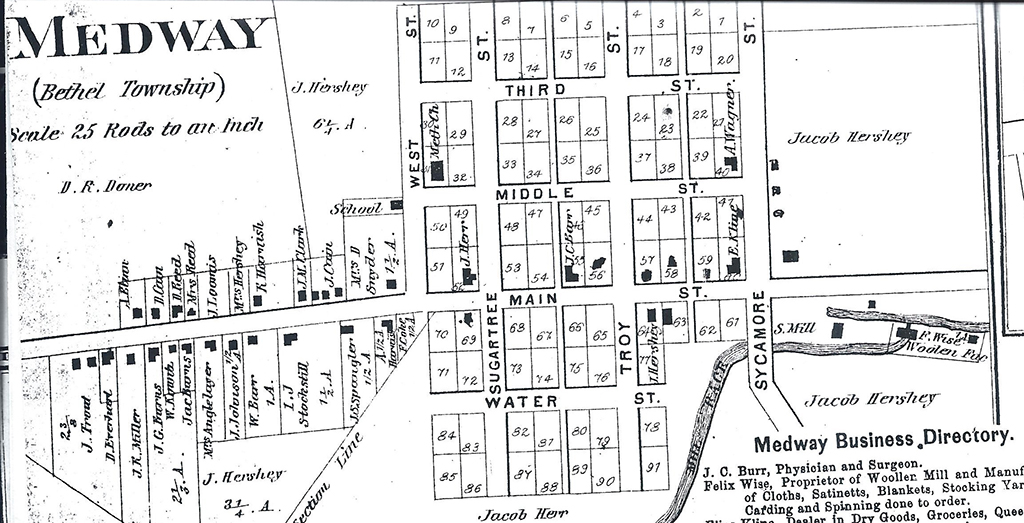
A drawing was kept. A plat was created with subdivisions of smaller lots drawn and numbered. Steele divided Medway proper into 89 lots. A rod was equal to 16.5 feet. Running 68 rods north from the corner of Sycamore Street and the mill race, lot #1 was measured off. Each lot was to be 8 rods deep and 5 rods wide. In feet, 82 ½ feet frontage and 132 feet deep. Lots ran from east to west starting on the north end, each street between and around being of 4 rods or 66 feet wide.
Streets included Sycamore as east boundary, West Street as west boundary. Running east to west down the middle was Main Street or Dayton-Miami Valley Pike (also known as Valley Pike, Mad River Valley Turnpike and later as Lower Valley Pike). East to west streets included Third Street, Middle Street on the upper section and Water Street south of Main. Streets running north and south included Sycamore, Troy Street, Sugartree Street and West Street. On August 24, 1816, the surveyor map and notes were acknowledged by Samuel Smith, a justice of the peace.
Reverend Steele did not stay in Medway. Sometime between 1815 and 1821 he built a house for his family in Monroe (New Carlisle). His wife Elizabeth died in November, 1827 and Archibald Steele died at the young age of 59 in April, 1831. He never got to see his town of Medway become populated.
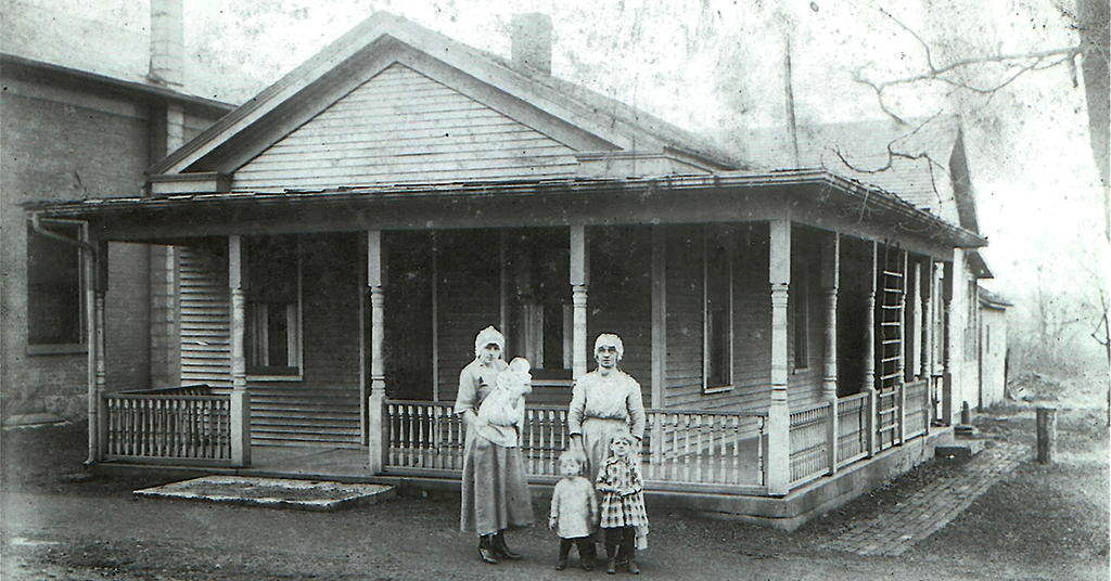
Medway did take a while to be built. The first house is said to have been built by Jacob Hershey who owned a large amount of the surrounding land. By this time (1830 or after) he was proprietor of McQueens Mill until it burned down, which was originally built by a man of that name. McQueen built the mill race to run his grist mill and also a saw mill. When Jacob Hershey bought the land in 1841, he extended the race. Archibald Lowry also ran a saw mill in the Medway area so there was plenty of lumber available for house building.
The summers of 1837 and 1840 saw J. Hershey purchasing land and lots in town. It is said that the previous owners, Archibald Steele’s heirs, owed back taxes and at one transaction of many, Hershey purchased 48 lots. Being a keen business man, Hershey knew that the race along the edge of town meant lucrative business opportunity, the lots in town would eventually be purchased and land around Medway would surely be developed into farms and additional homes. For instance, in 1861, Felix Wise purchased from Mr. Hershey a piece of land for a woolen mill along the race. Once built and running, other businesses followed suit.
By 1870, a business directory attached to the Atlas of Clarke County, Ohio by C. O. Titus, showed Felix Wise as Proprietor of Woolen Mill and Manufacturer of Cloths, Satinetts, Blankets, Stocking Yarns. Carding and Spinning done to order. Also listed was Elias Kline, Dealer of Dry Goods, Groceries, Queenware, Boots, Shoes, Hats, Caps, Notions, etc.
By now the town of Medway had grown beyond the 89 lots. On West Street, a school was built and heading west from there lots of irregular sizes lined both the north and south side of Main Street, with about 23 buildings established.
1880 saw a public telephone installed in Elias Kline’s store. A community attracts doctors, Medway having Dr. Shackleford, Dr. Barr, Dr. Stonebarger, Dr. Meranda and others throughout those early years. By this time, Medway was a busy village with bricklayers such as the Kline brothers, bridge builder (Jacob Hartman), building contractors including J. Hawthorn, David Reed, Frank McAdam and others, a butcher shop owned by J. Kunkle and later J. Metz.
A carriage shop was located on the lot at 207 W. Main, a cooper’s shop was in the area, Mrs. Anna Doner was a dressmaker, besides the general store another grocery was doing business at 129 West Main.
Three harness shops, a painter, a photographer, a plasterer, a factory for building rakes and corn shellers, shoe shops, a tailor shop, an undertaking business and weavers were all established in good time.
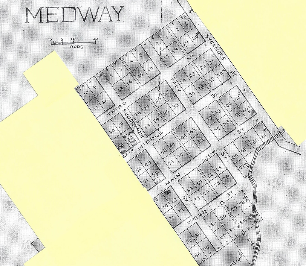
By 1894 the Recorder’s Office listed the following as owning the original lots that Archibald Steele platted off. Houses were built on numerous lots, usually of the clapboard style or brick.
- C. Brosey=Lots 66, 75, 78-80, 87-89
- F. Fletcher=Lots 46, 47, 54, 55
- A. Flath=Lots 67, 74
- S. Focht=Lot 63
- D. B. and S. Harnish=Lots 43, 58
- J. Hershey, Sr.=Lots 1-28, 33-39, 41, 48
- H. Harnish=Lots 49-52
- H. Huffman=Lots 42, 59
- T. A. Kline=Lot 60
- F. Koch=Lots 70, 71
- M. Schatz=Lots 68, 69, 72, 73
- B. F. Shartle=Lots 81-86
- J. Trout Jr.=Lots 45, 56
- M. Thornton=Lot 53
- Wise/Hern or Herr=Lots 61, 62
- E. Wagner=Lot 40
- J. L. Wise=Lots 63-65, 76, 77
- A. Wisler=Lots 44, 57
Next month part 3: Glad to Meet You Neighbor.